The Tam Giang - Cau Hai lagoon system is the largest lagoon in Viet Nam [1]. Due to the high diversity of aquatic habitats, there is a wide range of marine and brackish water species in the lagoon. Hence, The Tam Giang lagoon has always been a rich source for fishing [2]. Since its introduction in 1987, aquaculture spread rapidly in the region [3]. Nowadays, aquaculture plays a central economic and social role in the lagoon, e.g. as the main source of income for many households [2]. Nhung et al. 2015 differentiate between three different types of aquaculture in the region: Earth pond, net/bamboo stake ponds and net-enclosure. In the ponds mud crab, tiger shrimp and kinh fish are often cultivated simultaneously. The net enclosures in the water are dominantly used to farm freshwater carp [5].
In their study about the environmental condition of the lagoon, Thrang et al. 2021 point out that the environmental quality has decreased drastically from 1995 to the present. The concentration of organic matter and nutrients increased by 1.6-4.5 times and 1.5-2.2 times in the water, respectively [1]. As the water exchange in the lagoon is limited, wastewater from residential areas, agriculture, industry and aquaculture accumulate in the water, especially in the rainy season [1]. Further, the increasing amount of aquaculture structures reduces the water circulation, causing a build-up of contaminants in the lagoon [5].
Therefore, monitoring the extent and dynamics of aquaculture is of high interest. Earth observation by satellite data is a valuable tool to gain insights into aquaculture in the region on a large temporal and spatial scale [6]. As Ottinger et al. 2017 demonstrated Sentinel-1 SAR data with high spatial resolution can be employed to separate aquaculture areas from natural waters based on their differential backscatter. SAR imagery is especially suited since it maps under all weather and daytime conditions, e.g. being independent of clouds. Map 1 shows a median image of all ascending VH acquisitions for the year 2021. Using the Otsu threshold [7], earth pond aquaculture was detected. Net/bamboo stake ponds and aquaculture net enclosure information were created by visually interpreting very high-resolution optical imagery. The corresponding aquaculture areas are presented in Map 2. Almost the entire coastline is covered by earth pond aquaculture, only in Đầm Cầu Hai in the south are some free stretches of coastline. Net/bamboo stake ponds exist mainly in the Đầm Sam area of the lagoon. The net enclosure aquaculture extends as parallel structures along the entire length of the lagoon, especially in the northern and southern parts. In total, aquaculture in earthen ponds accounts for about 34.466 km², while 21.325 km² are managed in net/bamboo pile ponds.
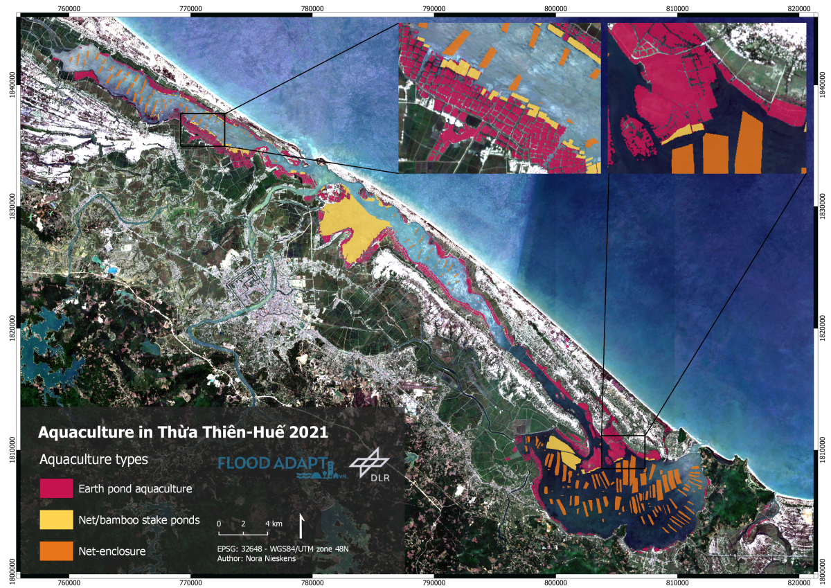
Figure 1: Aquaculture in Thua Thien Hue in 2021.
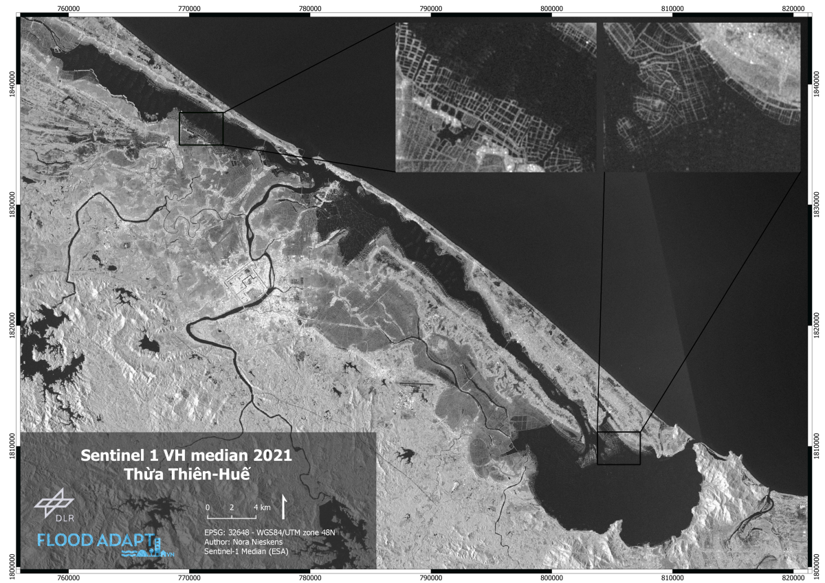
Figure 2: Sentinel-1 served as source data for the aquaculture assessment.
Literature
[1] Trang, C.; Thanh, T.; Thanh, T.; Vinh, V.; Tu, T. (2021): Assessment of the environmental carrying capacity of pollutants in Tam Giang-Cau Hai Lagoon (Viet Nam) and solutions for the environment protection of the lagoon. In: The Science of the total environment 762, p. 143.
[2] Carbonetti, B.; Pomeroy, R.; Richards, D. (2014): Overcoming the lack of political will in small scale fisheries. In: Marine Policy 44, p. 295–301.
[3] Binh T. (2002): The effects of aquaculture development on mobile gear fishing households in Tan Duong. In: Brzeski VJ, Veronika J, Newkirk GF, editors. Lessons in resource management from the Tam Giang lagoon. Hanoi: The Gioi Publisher, p. 99-114.
[4] Nhung, P.; Momtaz, S.; Zimmerman, K.; Bach D.: Factors affecting the conflict between fishing community and agricultural community: a case study of Tam Giang Lagoon in the central of Vietnam. In: Asia Pacific Journal of Advanced Business and Social Studies 1, p.228-238
[5] Boonstra, W.; Hanh, T. (2015): Adaptation to climate change as social–ecological trap: a case study of fishing and aquaculture in the Tam Giang Lagoon, Vietnam. In: Environ Dev Sustain 17 (6), p. 1527–1544.
[6] Ottinger, M.; Clauss, K.; Kuenzer, C. (2017): Large-Scale Assessment of Coastal Aquaculture Ponds with Sentinel-1 Time Series Data. In: Remote Sensing 9 (5), p. 440.
[7] Otsu, N. (1979): Threshold Selection Method from Gray-Level Histograms. In: IEEE Trans. Syst. Man. Cybern. 9, p. 62–66.