This page is not yet translated into the language "vi", so the english page is displayed.
Estuarine and coastal ecosystems belong to the most heavily used and threatened natural systems worldwide (Barbier et al. 2011). Currently, more than 40 % of the world’s population lives in coastal regions, a quarter of which situated less than 10 meters above sea level (UN 2017). Floods, saltwater intrusion, tsunamis, subsidence and erosion are among the natural risks to which coasts are exposed (Small and Nicholls 2003). The coastal zone of Vietnam is particularly vulnerable to these risks due to an increasing population density at a low-lying level (Rentschler et al. 2020). Global change increases the pressure on the coast (Oppenheimer et al. 2019; Wolanski et al. 2019). Therefore, a profound understanding and monitoring of coastal processes is crucial to protect a large number of people in the face of a changing world.
Coastline change analysis for Huế province in Vietnam was conducted for a time series from 1984 to 2021. The analysis is based on Landsat-derived annual 75th percentile Modified Normalized Difference Water Index (MNDWI) composites, representing the mean high-water level. Sub-pixel contours were extracted and manually cleaned from small inland water bodies. Linear regressions were calculated along shore-normal transects for quantifying coastline change rates. A hotspot analysis identified coastal segments with highest erosion and accretion rates. Coastal segments are considered hotspots when five neighboring transects are either erosional or accretional with a mean change rate of at least 3 m/yr. The transects have a distance of 100 m, which means that a hotspot includes at least 500 m of coastline. A validation of the automatic Landsat-based coastline detection yielded a sub-pixel accuracy of 8 m on a single Landsat acquisition.
The coastline change quantification for Huế province showed that more than half of the coast has been classified as predominantly stable with annual change rates of around 0.5 m/yr. However, 26 % of Huế’s coast was found to be erosional with change rates higher than -0,5 m/yr on average, while 20 % mainly accreted with more than 0.5 m/yr. Hence, the total of Huế’s coasts slightly eroded by -0.13 m/yr on average. Coastline change rates within the province are highly dynamic with maximum erosion rates of -15 m/yr and maximum accretion rates of + 18 m/yr.
Five hotspots with “severe” coastline change rates have been identified for Huế province. Three of which are erosional and two accretional. The erosion hotspot number 1 is located at the lagoon outlet in Thái Dương Thượng about 10 km from Huế city. It shows an average erosion rate of -4 m/yr and a length of 900 m. The erosional process has not been constant over time. While strong erosion started only in the 2000s, accretion predominated at the hotspot from 1988 to 1999. After 2014 the coastline dynamics stabilized. On the opposite side of the lagoon outlet, the reverse pattern could be observed. The headland has been classified as accretion hotspot with average accretion rates of +3 m/yr and a length of 1700 m. Phases of erosion and accretion also alternated here. Both processes are most likely linked through sediment redistribution. Severe erosion hotspots have further been identified north (number 2) and south (number 3) of the lagoon outlet in Hiền An in the South of Huế province. The average erosion rate lies between -3 and -4 m/yr and stretches over a distance of more than 5 km, only interrupted by the lagoon outlet. The coastal erosion has been rather constant and is not accompanied by equivalent accretion in the neighboring segment, indicating a deficit in the local sediment budget. Severe accretion hotspot number 2 is located North of Bính An with an average change rate of + 9 m/ yr. According to visual interpretation, the accretion has been caused by the construction of a new harbor.
Overall, even though most parts of Hue’s coastline remained stable over the past 35 years, strong coastline changes have been observed locally. The causes for coastline changes are multiple and interrelated. But it is reasonable to conclude that the erosion hotspots in Hue were caused by dynamic sediment redistribution as well as reduced coastal sediment availability. Accretion emerged both through natural sediment displacement and as a result of direct human intervention through construction and land reclamation.
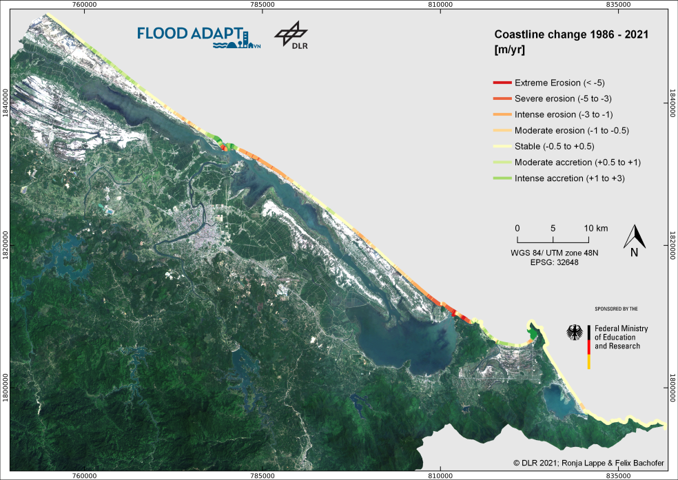
Figure 1: Coastline change 1986-2021.
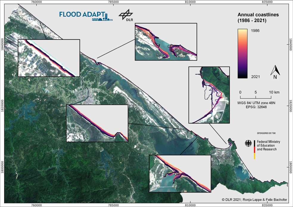
Figure 2: Annual coastlines 1986-2021.
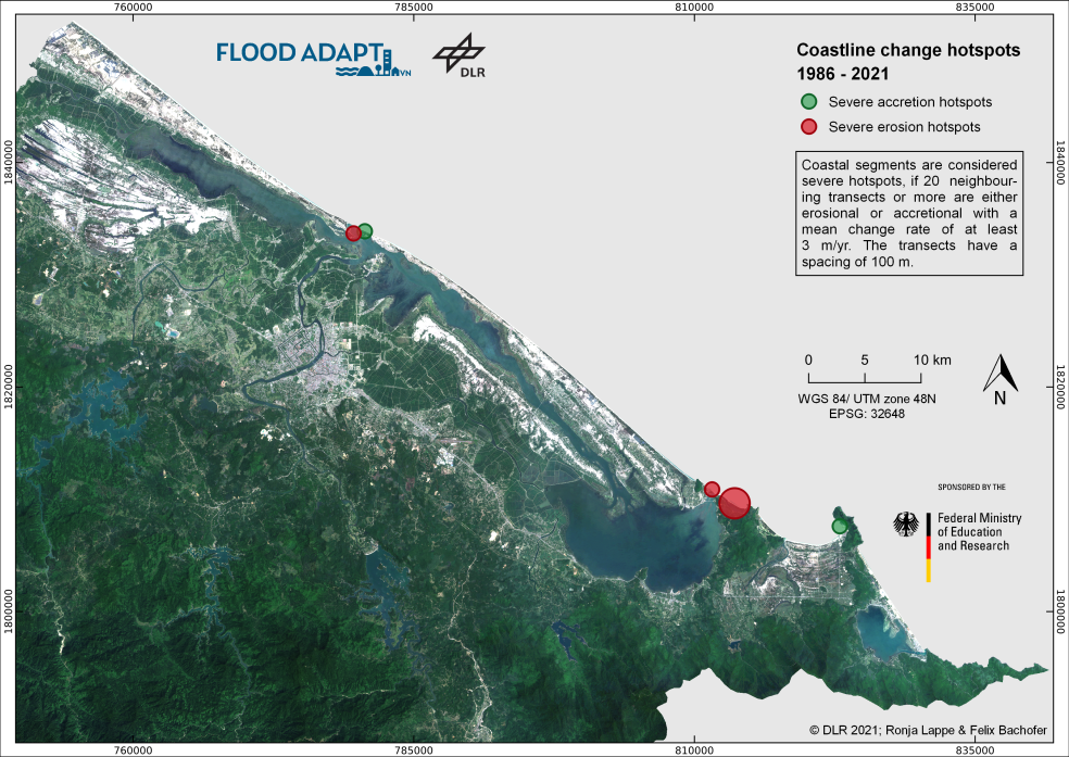
Figure 3: Coastline change hotspots 1986-2021.
References
Barbier, E. B. et al. (May 2011). “The Value of Estuarine and Coastal Ecosystem Services”. en. In: Ecological Monographs 81.2, pp. 169–193. DOI: 10.1890/10-1510.1
Oppenheimer, M. et al. (2019). “Sea Level Rise and Implications for Low-Lying Islands, Coasts and Communities”. In: IPCC Special Report on the Ocean and Cryosphere in a Changing Climate. In Press.
Rentschler, J. et al. (2020). Resilient Shores: Vietnam’s Coastal Development Between Opportunity and Disaster Risk. Tech. rep. Washington, D.C.: World Bank.
Small, C. and R. J. Nicholls (2003). “A Global Analysis of Human Settlement in Coastal Zones”. In: Journal of Coastal Research 19.3, pp. 584–599.
UN (2017). “Ocean Fact Sheet”. In: The Ocean Conference, United Nations. New York: United Nations.
Wolanski, E. et al. (2019). Coasts and Estuaries: The Future. English.